


CHASE ARCHIVES
Monsoon Season
2013
My best monsoon chase season to date. I began with my first chase on July 3 and ended with the last chase on September 9, concentrating solely on Southern California. I had planned on chasing in Arizona but timing and conflicts kept me west of the Colorado River. There were a total of 25 chases attempted between this time period, with about 40 chaseable days total between June 28 and September 11. Some of the best structure I had ever encountered, including an epic mesocyclonic wall cloud over Riverside, CA on August 29. Exhausting at times, but it was the experience and challenge I needed.
July 3, 2013
First chase of the season. Pre-dawn thunderstorms north of 29 Palms moving nw towards Barstow. Departed 4am to Barstow and intercepted outflow triggered cell west of Barstow shortly after sunrise.

July 11, 2013
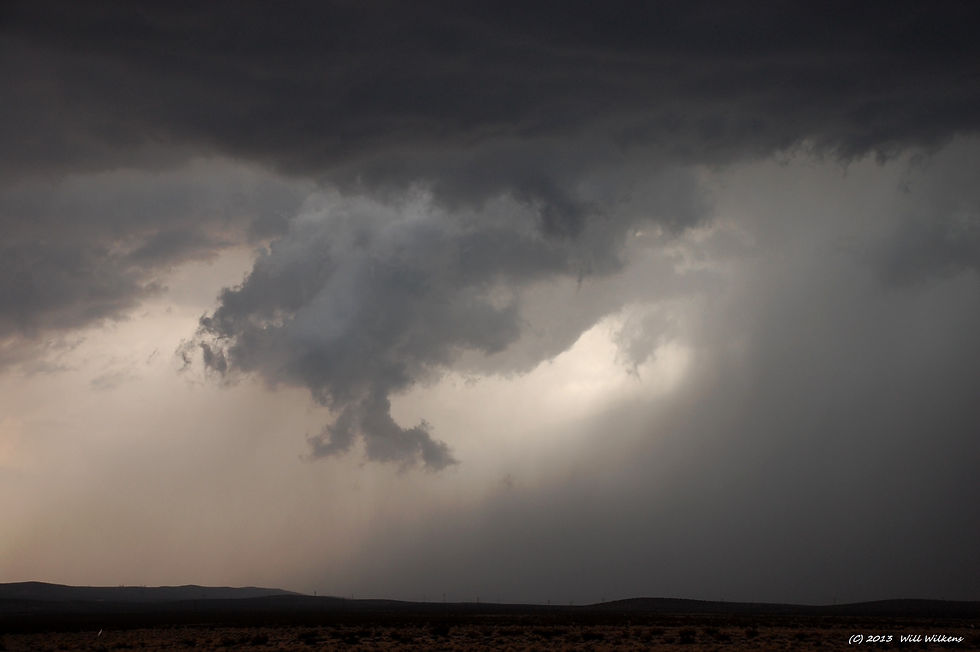
Several organized thunderstorms formed in eastern Riverside County, CA near Blythe. Intercepted around 7:30pm along I-10. Heavy rain and some interesting structure were the highlights. Storms were sub-severe and disippated at sunset. Rewarded with an amazing sunset.


July 14, 2013
Chase in the Mojave Desert in eastern San Bernardino County, CA. Nice structure, and watched lightning along Essex Rd.


July 20, 2013
Tropical wave moving through northern Inland Empire region with weak convection in embedded stratoform cloud shield. Some thunderstorms in Yucaipa and San Bernardino areas, but I ended up in Riverside in an area of general rains and eventually gave up the chase when the convection ended. No video or images.
July 21, 2013
Just after midnight an MCS which had pummeled Las Vegas a few hrs earlier moved southwest into California and traversed across the Mojave Desert and was almost 100 miles wide by the time it neared the southern areas of San Bernardino County. At 3am lightning was visible from my house and I decided to do a pre-dawn intercept. I first targeted Beaumont as the line of storms banked up against the San Bernardino Mtns. Unfortunately they began to weaken but the eastern flank was able to cross into the Cabazon and Palm Springs area and southward through the San Jacinto Mtns and Coachella Valley. I was able to watch some limited lightning in Beaumont and again in Cabazon. I attempted to reposition south in Hemet as the storm appeared to want to move across into that area but I abandoned the chase after sunrise when it appeared the storms were going to stay along the mtns, and I had a commitment with family for the remainder of the day.
July 22, 2013
Amazing chase in the Mojave Desert in western San Bernardino County, CA, around Barstow and Kramer Jct. Incredible structure such as wall clouds and rotating updrafts! One of the top four best chases this season and by far one of my best chases in the Mojave Desert, ever! Intercepted a total of 5 storms, 2 of which were severe. Storm #1 and #2 had weak rotation and produced wall clouds. Storm #5 which was a series of training storms along the El Mirage CZ boundary from Adelanto to Kramer Jct produced rotating updrafts, wall clouds, an RFD cut, and flash flooding. The chase began with an intercept north of Victorville and sighting of an impressive wall cloud 5 miles east of I-15. Storm #2 rotated and moved north between Barstow and Daggett with impressive rotation and wall cloud. Storm #3 went severe over Yermo with 1" hail. Storm #4 was an isolated cell north of Newberry Springs. Finally, storm #5 was a series of training cells along the EMCZ with mindblowing supercell stucture just south of Kramer Jct. I punched west along SR 58 and staged 3 miles east of Kramer Jct during the peak of the storm cycles.


July 26, 2013
What appeared to be a potentially decent chase setup in the Mojave Desert near Barstow, CA ended up being a disappointment as early storms that had fired in that area cycled out and the entire area stabilized in the late afternoon. I was able to arrive in Barstow just in time to capture some mammatus, but that was about it.

July 27, 2013
Boundary interaction in the Victorville/Barstow area of western San Bernardino County, CA triggered sub-severe convection between Barstow and Newberry Springs near sunset. Georgeous structure and sunset in Barstow.


August 18, 2013
Mojave Desert in western San Bernardino County, CA. Similar setup to July 22 day. Initial cells from Victorville to Barstow produced a landspout near Helendale. Stationary storms later formed along convergence boundary from Adelanto to Boron, CA. Some of these cells were rotating with incredible structure! Outflows from daylight storms caused a resurgence of activity around 10pm north of Barstow with spectacular lightning. Storms continued through the night.


August 19, 2013
An unabated continuation of the previous day's activities, storm activity continued into the night of the 18th and predawn hours of the 19th. Storms erupted in the Inland Empire region before dawn with spectacular lightning at my house in Lake Elsinore around 5am. Later in the afternoon storms fired in the Adelanto area once again but I was not able to intercept them in time and rerouted to the Antelope Valley area of northern Los Angeles County as storms fired along a boundary zone in that area. One particular storm over Palmdale went severe and traversed north over Lancaster and eventually weakened over Mojave. Other storms over Bakersfield and the Tehachapi Mtns were observed, but opted not to intercept due to time and distance factors.


August 22, 2013
During the afternoon a very lage MCS formed in western Arizona and moved west crossing the Colorado River into California between Parker and Yuma. This MCS produced a strong outflow boundary and subsequent dust storm that travelled west into the Coachella Valley by 8pm. This boundary triggered thunderstorms from Indio south to Borrego Springs which had lightning that was visible for over 100 miles away over the Pacific Ocean. I intercepted the first cell in Indio just as the dust storm arrived reducing my visibility to less than 100 yards at times, but mainly to about 1/2 mile. This deteriorated my ability to video and photograph lightning. I continued south to just west of Mecca to intercept one final storm around 10pm but the lightning was mostly intracloud and the lingering dust made viewing impossible.


August 23, 2013
Attempted a late afternoon intercept of some storms over Newberry Springs, CA, but they all cycled out by the time I reached Hesperia. Further development was too far to the northeast near Afton, moving northeast. Abandoned the chase. No video or images.
August 25, 2013
Interesting day as remnant low level moisture from tropical storm Ivo over central baja moves up through the Coachella Valley and into the 29 Palms area. Severe thunderstorms fired along the San Jacinto/Santa Rosa Mtns, Indio, and Morongo Valley areas causing flash flooding. One storm over Morongo Valley had ample low level southeasterly shear to cause weak mesocyclonic rotation with brief wall clouds. Flash flood video shown below while storm footage with wall cloud rotation will be uploaded soon. One interesting aspect to this chase was the massive dust devils that I intercepted in Perris while en route to Morongo Valley. These were the largest dust devils I have ever experienced and were as big as weak tornadoes in my honest opinion.


August 26, 2013
Moisture from previous day settled across the Inland Empire. Some weak convective activy formed over the Corona and Orange County areas in the early afternoon, while later activity was focused over Temecula. I attempted a chase in these two areas but neither experience produced anything spectacular.

August 27, 2013
While waiting for the 'cap' to break in Perris I observed very large and impressive dust devils and took pursuit. Intercepted three, in Perris, Nuevo, and Romoland. Otherwise, storm towers that had tried to form along the eastern end of the ECZ would not develop into storms, so chase was abandoned.


August 29, 2013
A stationary severe thunderstorm over the downtown district of Riverside, CA dumped nearly 3 inches of rain in 30 minutes, quarter-sized hail, and 70 mph winds around 3pm during an intense microburst. Flooding, downed power lines, and felled trees caused SR 91 freeway and several major surface streets to be shutdown for several hours. I staged in Perris watching a weaker cell there get pulled in and merged with the Riverside cell. I repositioned north on the east side of Riverside and watched the storm sit stationary with incredible structure. It exhibited rotation and produced an amazing plains-class wall cloud that rotated and spiraled into the base of the storm. Storm tops were as high as 52k ft! Due to the road closures caused by the flooding and damage around the downtown area I was not able to investigate the scenes.


August 30, 2013
A classic Elsinore Convergence Zone (ECZ) scenario over Perris, CA. Line of convection formed along boundary that stretched in a line from north Lake Elsinore to Nuevo. Two distinct cells formed and congealed forming a rotating wall cloud directly over Perris. As the two storms merged into a single organized storm it went severe causing 60mph winds and very heavy rains that triggered flash flooding on the north side of Perris. I staged in Perris as the storm unfolded capturing amazing images of the wall cloud that rotated almost directly overhead.


August 31, 2013
After busting in Lake Elsinore during a briefly promising setup along the ECZ, I decided to go north into the Mojave Desert as boundary interactions erupted during the late afternoon. Unfortunately my timing was off and storms along the boundary in Adelanto cycled out by the time I arrived around 5pm. I continued north on I-15 to Afton (30 mi e of Barstow) and waited for a vigorous line of storms 30 miles to the north to move south towards me. Unfortunately, these storms were moving at a measly 1kt and after 3 hrs of watching distant lightning taunt me, I ended the chase. However, my efforts were not completely thwarted as I was rewarded with amazing civil twilight off the distant storms to my north.


September 2, 2013
ECZ boundary erupted with two storms on each far-end flank. Main storm fired on east end in Hemet, moving slowly northwest towards Lakeview. As it built into Lakeview it produced a small cone funnel cloud that last 4 1/2 minutes. The most ironic part of this experience was the fact I did not notice the funnel until the last 2 minutes of its lifecycle. After reviewing video I was amazed to find that I had captured its full life cycle as it formed ahead of me. The funnel comes into view as I turn right (east) onto Nuevo Rd in the town of Nuevo. After passing through Nuevo two minutes later, I take notice of the funnel before veering towards Lakeview. The funnel was not very long in length, more like a cone, but was visually acute, and noticeabley rotating, twisting, and morphing. Another ironic moment is that I completely neglected to take pictures of it with either my dslr or iPhone, as I was busily distracted positioning the video camera and gawking at it in amazement. The west-end storm fired on the north side of Lake Elsinore nearly overhead my neighborhood. It was a narrow storm that had towered over 50kt ft. It also had shown rotation, and looked briefly like a mini LP supercell. I was able to capture the last moments of its life cycle to my west as the Lakeview cell weakened and veered north towards Beaumont.


September 3, 2013
Core-punched a severe thunderstorm that moved north off the San Jacinto Mtns and crossed over Cabazon and Banning. As it continued to move north over the San Bernardino Mtns into Lucerne Valley I decided to relocate to the Mojave Desert as storms were now firing along the El Mirage CZ (EMCZ) from Adelanto to north of Barstow. However, the storms over Adelanto cycled out by the time I arrived in Victorville, so I decided to drive north on old US 66 to Helendale to explore this route since I never been on this road before. When I got to Silver Lakes I was treated to a gorgeous civil twilight sunset that illuminated the storm 20 miles north of Barstow.


September 4, 2013
Several severe thunderstorms over the San Jacinto and Santa Rosa Mtns triggered a strong outflow and dust storm that moved northwest across the southern Inland Empire. This also triggered weaker thunderstorms along the ECZ boundary in Canyon Lake, Perris, and Lake Matthews. Intercepted the dust storm on the north side of Lake Elsinore that had undercut developing thunderstorms and impeded their development. Repositioned in south Corona and observed a thunderstorm over Lake Matthews that produced a shear funnel.


September 5, 2013
Strong sub-severe storm over Hemet moved northwest towards Homeland and Lakeview. I captured on video what appeared to be a landspout on the east side of Homeland but it remains respectfuly disputed by NWS whether it was actually attached to the base of the storm or not. Nonetheless it was impressive looking. I opted to break away from this particular storm which was moving north into San Jacinto and stage in Perris as impressive towers were forming along the ECZ boundary directly over town. Unfortunately they did not reach full convective initiation, and I discontinued the chase.


September 6, 2013
Strong thunderstorms over the Coachella Valley, San Jacinto Mtns, and Santa Rosa Mtns produced outflow triggered towering along the ECZ boundary in Meniffee, Perris, and Beaumont areas. Attempted all three ECZ targets and then abandoned the chase when convective initiation could not be reached. No video or images.
September 8, 2013
After originally planning to target severe storms over the Indio area of Coachella Valley I decided to target the Mojave Desert near Newberry Springs as the Indio storms cycled down upon my departure and new activity ramped up in the Mojave. After numerous weak convective cells passing southward I noticed a line of storms ramping up 20 miles north of Barstow around sunset. They were moving south so I repositioned in Barstow and watched distant lightning for a couple of hours as the storms kept dying within 15 miles of Barstow. Upon deciding to abandon the chase a new storm fired directly over Daggett at 10pm. I drove from Lenwood to the east side of Barstow and captured some amazing lightning on video. The activity continued south to Apple and Lucerne Valleys and all the way south to Indio through the night. I attempted an Apple Valley intercept on my way home but the lightning was sporadic and too embedded.


September 9, 2013
The last chase of the monsoon season. An Inland Empire chase which began in Perris and ended in Chino Hills. After watching a potential line of convection forming just east of Perris I decided to target new development directy over the eastern San Gabriel Mtns that began moving slowly southwest over Upland around sunset. As I arrived in Devore my timing was less than perfect and could never get any decent video of the lightning while parked. As I repositioned in Rancho Cucamonga and then Ontario I experienced vivid lightning while driving, but never while parked. The storm cells expanded across the entire Chino and Ontario area before disippating around 9pm.

